FOEL FRAS SUMMIT.

FOEL FRAS SUMMIT.

Thursday 31 March 2011

#21.Hawarden Hike.28-3-11.

Today's walk came from the "Rural walks in Flintshire" booklet again.This was a last minute decision as Julie was working until 3P.M. and when she got home i said "get your boot's were going for a walk",15 minutes later we were getting them on in the car park at the top of Tinkersdale in Hawarden.The booklet suggest's going across the golf course but as it was a lovely sunny afternoon i assumed there would be a few golfer's out so we left this section out and walked south on the A550 until we came to a lane on our left hand side about half way down the road,we turned off the A550 up this lane until it peter's out at the fence by the A55.

We turned left through the staggered entrance and walked down the old road until we reached the village of Warren

.Just after passing the Spinning Wheel Inn we turned left onto a lane marked Cherry Orchard Farm.We crossed a cattle grid and passed the entrance to Cherry Orchard House and continued down this quiet lane.

Here there are some far reaching view's to the east looking across the Cheshire Plain,and the eyesore that is the Airbus Factory at Broughton,(my father worked here for over 25 year's until retirement and my brother Konrad has been employed there for nearly 40 year's!).
 
 Continuing down the lane we could see the ruined Hawarden Old Castle in the ground's of the Hawarden estate.This ruin was built in the 13th century and was used by Edward 1st as a base for his invasion of Wales.It was captured by Dafydd,brother of Welsh Prince,Llewelyn ap Gruffudd,in 1282.Good old Daf,if he was alive today i would buy him a pint.In the 17th century it suffered severe damage during the Civil War when it was defended by the Parliamentary side.

The path now enter's Bilberry Wood and is waymarked.After a short distance we got a glimpse of the "New" Castle.Here 4 time's Prime Minister of Britain William E Gladstone use to live after his marriage to Catherine Glynne,heiress to the Hawarden Estate.The family still live here.

The path follow's a wall through the wood and eventually you reach the ruined 18th century corn mill.The mill wheel and much of the machinery still remain's.


A short walk brought us back to the car park.The distance was 3.5 miles with 250 feet of ascent.


MILEAGE           145
ASCENT             36,400
TOPS                  44.

Sunday 20 March 2011

#20.Gorllwyn and Drygarn Fawr.19-3-11.

These are 2 Nuttalls that Howie needed to knock off his list so he put it up as a "meet up" on the walking forum to see if anybody wanted to join us and we had a nice little walking party that consisted of me,Julie,Howie,Joester,Abs and their 3 lovely daughter's Chloe,Poppy and Bea,Yamyam,Sharon,Jim,Janine,Paul,Theresa and their dog Sweep.The weather forecast was for an overnight frost followed by a sunny day.
     Howie picked us up at 7a.m. and we made the 70 mile journey to Rhayader in 1 hour 30 minute's.We stopped at the  Caban Coch reservoir dam to take a few photo's as it was a lovely sunny morning.


We then drove the short distance to the adjacent reservoir,Carreg-ddu and stopped for a few photo's again.These 2 dam's are separated by a submerged dam topped with a road bridge.Water is taken out at the Foel Tower and it flow's by gravity all the way to Birmingham 73 miles away.


We drove across the bridge and made our way to the car park at Llanerch Cawr,this is only a small car park and when we got there is was being used to store timber from some recent tree felling.We managed to squeeze all 4 car's on in one corner,Paul had parked a short distance away.Before we set off Abs and little Bea gave me a present.I opened it to reveal a knitted hat of a Welsh Dragon,i was well chuffed and wore it all day.


We crossed the Afon Claerddu on the new bridge which stand's beside's it's predecessor,seen below.

We followed the quarry track which crosses the Afon Marchnant.This rise's gently but gave us some nice view's back to the reservoir.


After 1 mile and 400 feet of ascent we reached the disused quarry.Stone from here was used to construct the 184 foot curved dam of the Claerwen reservoir that took 6 year's to construct.


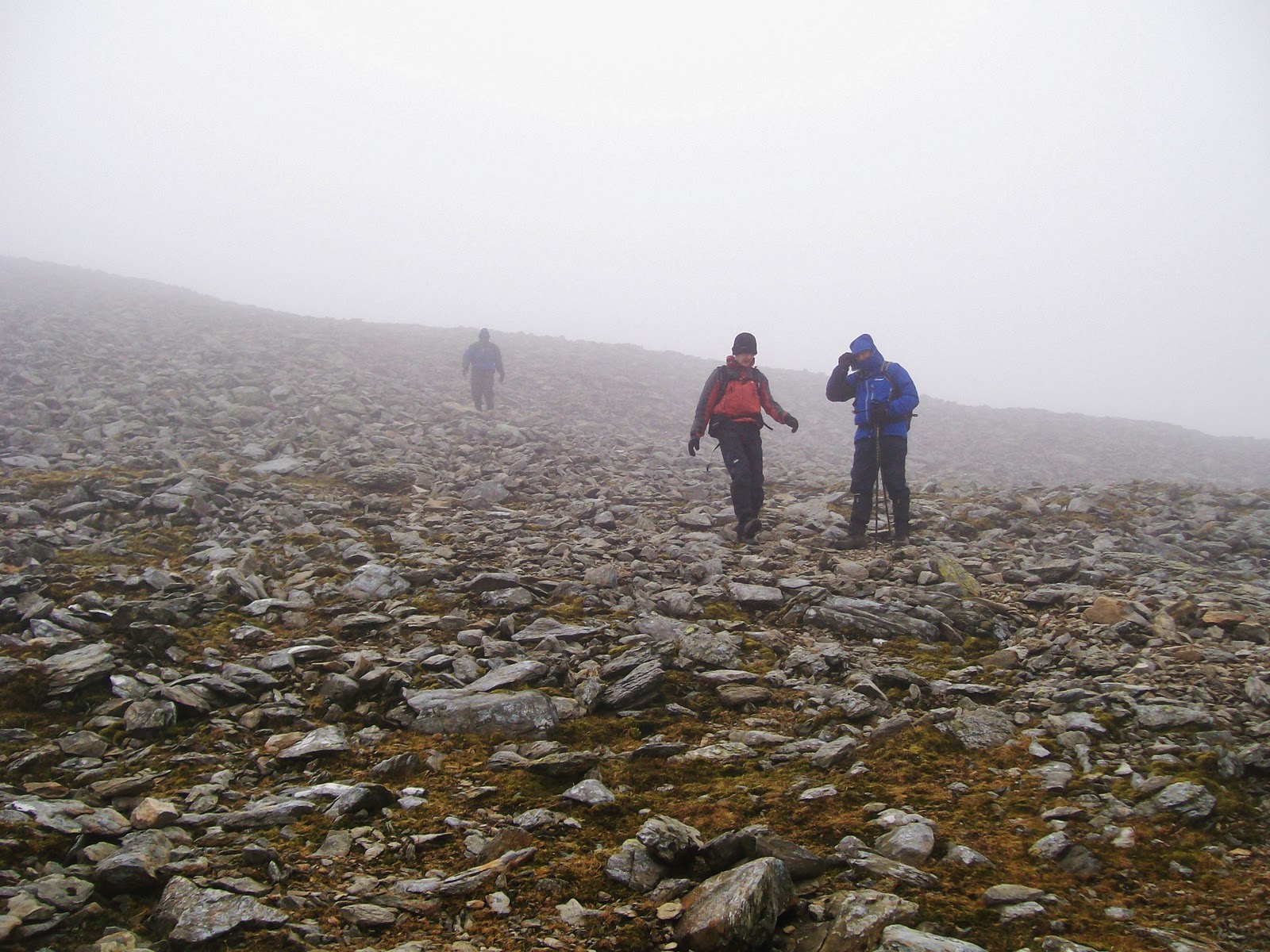
Poppy and Chloe were keeping me entertained playing guessing game's and i-spy as we walked.We now walked out onto the open moorland,the path was vague as not many people visit these hill's but the view's were good.

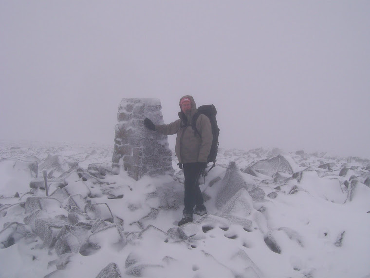
From the quarry it is just over 1 mile with another 800 feet of ascent to the summit of Gorllwyn.We rested by the cairn and wind shelter whilst a few other's walked the 300 metres north east to the OS trig point and hollowed out ancient cairn.

We could see the massive cairn's on Drygarn Fawr,3.8 mile's away in the distance but the terrain in between consisted of boggy ground,tussocky grass,hidden hole's and vague track's to follow.Apparently Victorian visitor's gave this area the nickname of "The Desert of Wales" !,i can see why.The term describes to the large area in Central Wales in the Cambrian Mountains known locally as "Elynydd" and got the moniker through the lack of road's and town's.


After crossing the Bwlch y Ddau Faen we walked the last 400 feet of ascent up to the impressive beehive cairn's on top of Drygarn Fawr.In English it translate's to 3 large cairn,s but there are only 2 cairn's here?.The origin's of these cairn's are a mystery.They were built sufficiently long ago for much local knowledge to have been lost.The stone's themselves are from the original Bronze Age cairn's built between 2000 and 1500 BC.A    cairn on Drygarn Fawr,which was used as a trigonometrical station in 1851,was rebuilt in 1884 to commemorate the original one,but this was not used again by the OS as their concrete pillar was erected in 1936.The cairn's were repaired in 1920.


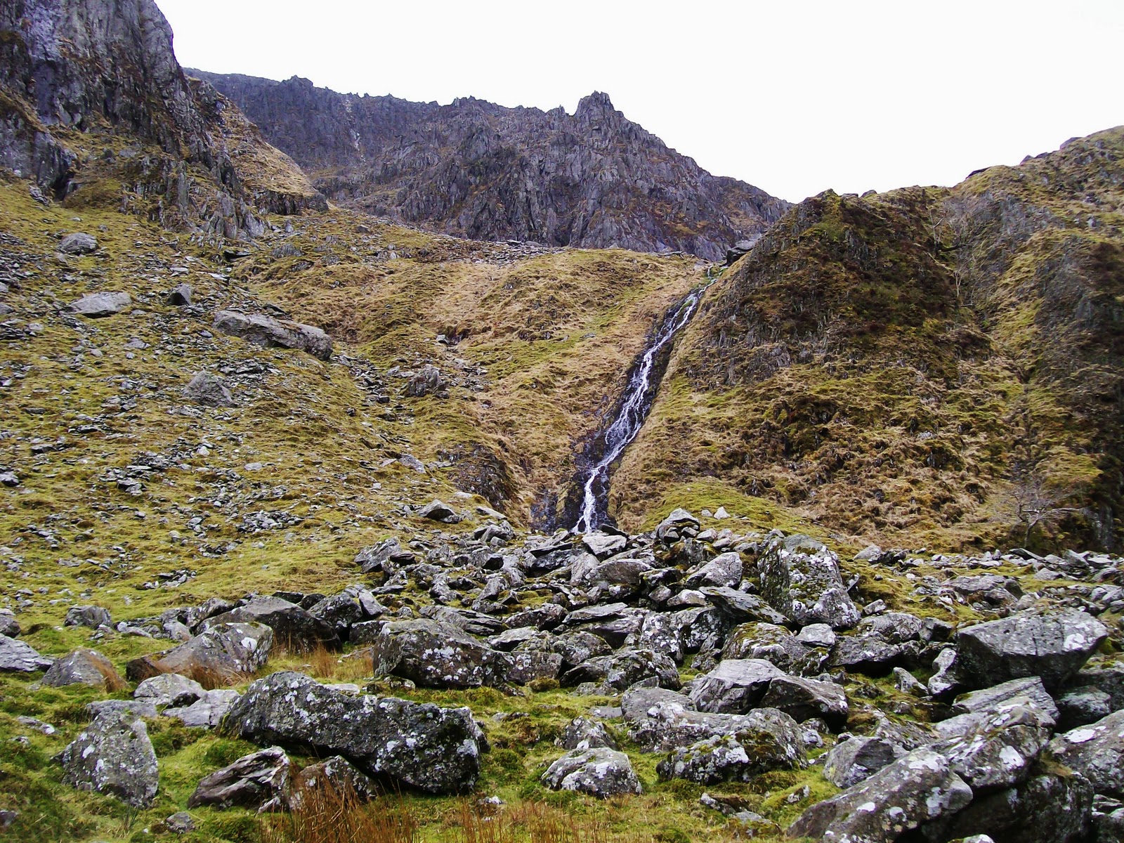
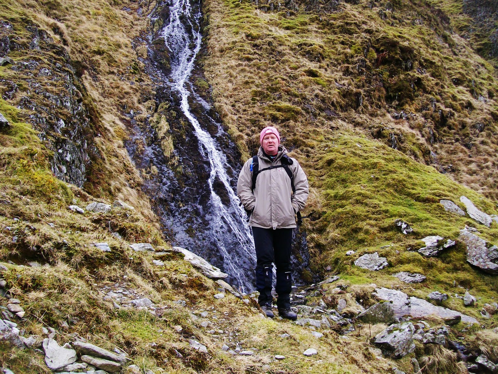
We headed north down to the Pant Glas and followed the Afon Rhiwnant.Again here the terrain is awful and it takes a long time to go a short way,but it is a pretty valley.


When me and Julie last did this walk 2 year's ago she had a nasty fall as we made one of the many river crossing's,slipping on some wet rock's.As we carefully crossed the stream under Dalrhiw Sharon slipped and fell in the shallow stream banging her elbow and hurting her hip and back.After a bit of cleaning up she was ok to carry on so i carried her bag for a while.At the difficult crossing where the Nant Paradwys meet's the Rhiwnant i was helping everybody cross,Theresa slipped and fell in.She got a lot wetter than Sharon but wasn't hurt as much,just broke one of her trekking poles.Once across this section it is a pleasant walk back to the car's.Here are a few photo's below.


Although we only walked 10 mile with 1850 feet of ascent,visiting 2 summit's,this was a bloody hard walk and took us nigh on 8 hour's.A great effort by everybody to get round,especially Poppy and Chloe who didn't moan once on the entire walk,although they very nearly talked me to death.A de-briefing in the Elan Hotel in Rhayader before everybody said there farewell's.Fantastic company to walk with.


MILEAGE          141.5
ASCENT            36,150
TOPS                  44.

Friday 11 March 2011

#19.Crib Lem Spur and Foel Meirch.10-3-11.

Crib Lem Spur has been on my to-do list for some time after reading a report on the walking forum and seeing the photo's of it.I asked a few friend's if they were available and had a few yes's so Killy(Andy Pierce) came to my house and i drove to the Rhug Estate farm shop where Howie was waiting for us,he jumped in the back and i drove to Gerlan above Bethesda to meet Peakbagger (Mike Cotton) at 9a.m. The weather driving there was very poor,heavy grey skies,raining quite heavily,very windy and low cloud covering the mountain top's.Driving down the A5 Tryfan was the only mountain that was clear of cloud,i said "shall we climb Tryfan instead" but Howie said to stick to our original plan stating the weather would improve,i was unsure but fair play it did stop raining by the time we reached Gerlan and the cloud lifted off the top's.
     It was cold getting our boot's on and very windy so we all put our wet coat's,hat's and gloves on and set off at 9.15a.m. Howie had bought a new coat,the hood being on the large side being able to cover a rock climber's head if he was wearing a helmet,he got some stick during the walk.

Up the lane leaving Gerlan and cross the Afon Llafar the path enter's the field's were we crossed the Afon Cenllusg and got our first view's of the high Carneddau.Below pictured Yr Elen on the left .

Carnedd Dafydd on left side or ridge and Pen Yr Ole Wen.

It was a 2.8 mile walk into Cwm Llafar to reach Llech Ddu,relatively flat following the river and below are a few photo's .


On Moel Siabod a few month's ago Howie lost his mat when the wind caught it and blew it away up into the sky never to be seen again.We came across this one and wondered if it was his.
Lower down the valley and sheltered from the wind i stupidly commented that we may be sheltered from it until we reach the summit.By the time we had crossed the last stile where the path split's for Mynydd Du we were back in the wind,it was roaring up the valley so strong that at one stage it launched me forward and i started running along the grassy track and couldn't stop,propelling me forward for over 100 metres before it subsided.
            Eventually we reached the awesome Llech Ddu at the bottom of the Crib Lem Spur.


The scramble ascend's a ridge above the cliff but a devious approach is needed to get to it.We climbed steeply into Cwmglas Bach using a vague path to the left of this waterfall pictured below.


We were all slightly apprehensive about the scramble with the wind being so strong but decided to crack on saying we could alway's drop back down if it was to dangerous.Here we were at a height of 1,650 feet and with the summit of Carnedd Dafydd being 3,425 feet we knew we were in for a tough climb.Below nearing the top of the waterfall.

Here a vague path goes left to arrive above Llech Ddu,shown below,where the scramble start's.

Below are photo's of the boy's on various stages of the scramble.


In places we just had to crouch low when the wind was gusting as the ridge was quite narrow but we cracked on and after reaching the top of the scramble the terrain get's a lot gentler being a stony grassy slope and we stopped for a drink and some food.It started to hail whilst we had our break.

The last couple of hundred feet to the summit was on a well walked path but we lost the view's as it was quite cloudy.At the summit we chatted to 2 men from Anglesey,the only people we saw all day.The summit of Carnedd Dafydd stand's 3,425 feet,1,044 metres,one of only 5 mountain's in Wales over 1,000 metres.Our intention was to walk over to Carnedd Llewelyn and Yr Elen but as the weather was so poor we decided to drop down through the rock's to Foel Meirch and follow the ridge over Mynydd Du back to Gerlan.The cloud soon dispersed to give us some good view's on the descent.


The Crib Lem ridge from Foel Meirch.

The wind was very strong descending trying to blow us into Cwm Llafar and we had to stay away from the edge.Below Mynydd Du,after crossing it the heaven's opened and we were caught in a heavy rain shower for 10 minute's.

A most enjoyable walk/scrable made interesting by the strong wind in great company.The length of the walk was 7 mile with 2,900 feet of ascent.


MILEAGE           131.5
ASCENT             34,300
TOPS                  42.